A devastating Tsunami in the Mediterranean every Century
Tsunamis can occur in European waters due to earthquakes caused by the African Plate drifting northwards underneath the Eurasian Plate. The Mediterranean Sea is considered vulnerable to tsunamis not only because the area is seismically active, but also because coastal ports are very close to high-risk tsunami epicentres. An earthquake in the Mediterranean could trigger a tsunami that could reach Cyprus within an hour, giving very little time to evacuate and shut down industrial buildings such as power plants and chemical factories. According to Dr. Georgious Georgiou, director of the Oceanography Centre of Cyprus.
To reinforce the facts above, a 6.7 Mag earthquake occurred on 20th July 2017 north of the Island of Kos which resulted in a tsunami which caused considerable damage to the north coast of the Island, wrecking the harbour and relocating boats which had been in the harbour inland
TWERC expansion of the CYCOFOS observatory. Mediterranean Quakes over 4.5 mag
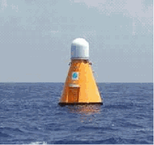
The buoy-powered ocean observatory that has been operating off the southern coast of Cyprus for a number of years has now undergone an extensive expansion and the prototype Tsunami Warning and Early Response System for Cyprus (TWERC) is now in operation. The CYCOFOS observatory incorporates two MCS OceanNET™ surface buoys to provide electrical power and satellitetelemetry for transmitting data to shore. The TWERC expansion connects the surface buoy with a CSnet Offshore Communications Backbone. Seafloor nodes (OceanWorks) join each leg of the array that are laid adjacent to the Eratosthenes Seamount. With continuous power and two-way broadband communications, TWERC is being used as a test bed to evaluate a number of different tsunami detection techniques. Initially both Ocean Bottom Seismometers (OBS - GURALP) and Bottom Pressure Recorders (BPR - Sonardyne) will be deployed at each node. Future plans include incorporation of a high-resolution, low-light level imaging system (SIDUS) at the protected deep water coral habitat at the base of the seamount. CYCOFOS and TWERC are operated by the Oceanography Centre of the University of Cyprus, a member of the IOC NEAMTWS
(North Eastern Atlantic and Mediterranean Tsunami Warning System).The location of the Buoys
are at the following co-ordinates. 33.41.9 N - 032.08.01E and 33.33.54N - 31.54.99E
The Sieberg-Ambraseys Tsunami Intensity Scale
1. Very light. Wave so weak as to be perceptible only on tide-gauge records.
2. Light. Wave noticed by those living along the shore and familiar with the sea. On very flat shores generally noticed.
3. Rather strong. Generally noticed. Flooding of gently sloping coasts. Light sailing vessels carried away on shore. Slight damage to light structures situated near the coasts. In estuaries reversal of the river flow some distance upstream.
4. Strong. Flooding of the shore to some depth. Light scouring on man-made ground. Embankments and dikes damaged. Light structures near the coasts damaged. Solid structures on the coast injured. Bid sailing vessels and small ships drifted inland or carried out to sea. Coasts littered with floating debris. 5. Very strong. General flooding of the shore to some depth. Quay-walls and solid structures near the sea damaged. Light structures destroyed. Severe scouring of cultivated land and littering of the coast with floating items and sea animals. With the exception of big ships all other type of vessels carried inland or out to sea. Big bores in estuary rivers. Harbor works damaged. People drowned. Wave Accompanied by strong roar.
6. Disastrous. Partial or complete destruction of manmade structures for some distance from the shore. Flooding of coasts to great depths. Big ships severely damaged. Trees uprooted or broken. Many casualties.
Some Facts
* Ten percent of all tsunamis worldwide occur in the Mediterranean.
* On average, one disastrous tsunami takes place in the Mediterranean region every century.
* Historical records report of many powerful tsunamis that have taken the lives of thousands over the ages.
* Greece and southern Italy are mostly affected.
PUBLICATIONS
Tsunami Preparedness
best practice guide
New Tsunami
Intensity Scales
A guide to tsunami's for hotels
Tsunami Warning Centres
West Cost & Alaska
Tsunami Warning Centre
NE Atlantic & Mediterranean
Tsunami Warning Systemm
Pacific Tsunami
Warning Centre
Indian Ocean
Tsunami Warning System
Joint Australian
Tsunami Warning Centre
International Tsunami
Information Centre
Further Related Links
Raising Tsunami Awareness
Iin the Mediterranean
Potential for Tsunamis
In the Mediterranean
Millions at risk from
Mediterranean Tsunami
Tsunami hazzard evaluation
Of the Mediterranean
Tsunami Awareness
Developing Tsunami early warning system
Preparing for tsunami's in the Mediterranean
Earthquakes in Cyprus Documentary
Scientists at work on Med Tsunami alert system
Mediterranean TSUNAMI would threaten 130 MILLION and leave large areas underwater.
Daily Express 28th August 2015
A TSUNAMI in the Mediterranean would affect 130 million people and wipe out huge swathes of coastal holiday destinations, new research has suggested.
Scientists developed a model to simulate the effects of the phenomena and found that a large tsunami, which occurs on average once a century in the Med, would leave 3.5 sq km of Crete under water.Southern Italy and Greece would be flooded and the whole region, including North Africa and Turkey, would be vulnerable to the giant waves caused by earthquakes.
The study published in the Ocean Science journal explained that risk to human life in Mediterranean coastal areas would be high because of the high population density. In addition, tsunami waves in the Mediterranean would need to travel a very short distance before hitting the coast, giving unsuspecting coastal dwellers little advance warning.
Though not as frequent as in the Pacific and Indian oceans, around 10% of tsunamis occur in the Mediterranean, mainly due to earthquakes generated when the African plate slides underneath the Eurasian plate.
The area has form for devastation caused by the huge waves.
In 365 AD a tsunami was generated by a clustering of earthquakes off the coast of Crete, the largest of which had a magnitude between 8.0 and 8.5. The tsunami destroyed ancient cities in Greece, Italy and Egypt, killing some 5000 people in Alexandria alone.
More recently in 1908 an earthquake of magnitude of about 7.0 hit the Messina region in Italy causing a tsunami that killed thousands, with waves exceeding 10 metres in height.
Study lead author Doctor Achilleas Samaras, a researcher at the University of Bologna in Italy, said: "We wanted to find out how coastal areas would be affected by tsunamis in a region that is not only the most active in the Mediterranean in terms of seismicity and tectonic movements, but has also experienced numerous tsunami events in the past." In their bid to discover the impact of another gigantic tsunami, the team developed a computer model to represent how tsunamis in the Med would hit the coast using information about the seafloor depth, shoreline and topography.
They then applied their model to tsunamis generated by earthquakes of approximately 7.0 magnitude off the coasts of eastern Sicily and southern Crete. In both cases, the tsunamis would inundate the low-lying coastal areas up to approximately 5 metres above sea level. Thankfully this indication of destruction is just a simulation and the researchers hope that the results will help governments to identify and protect vulnerable areas. Dr Samaras said: "The main gap in relevant knowledge in tsunami modelling is what happens when tsunami waves approach the near shore and run inland.
"The nearshore is the zone where waves transform - becoming steeper and changing their propagation direction - as they propagate over shallow water close to the shore. "We simulate tsunami generation by introducing earthquake-generated displacements at either the sea bed or the surface. "The model then simulates how these disturbances - the tsunami waves - propagate and are transformed as they reach the nearshore and inundate coastal areas."
"Although the simulated earthquake-induced tsunamis are not small, there has been a recorded history of significantly larger events, in terms of earthquake magnitude and mainshock areas, taking place in the region."
Dr Samaras also warns that an even larger earthquake could result in significantly more damage. He added: "Due to the complexity of the studied phenomena, one should not arbitrarily extend the validity of the presented results by assuming that a tsunami with a magnitude at generation five times larger, for example, would result in an inundation area five times larger, it is reasonable, however, to consider such results as indicative of how different areas in each region would be affected by larger events.
"Our simulations could be used to help public authorities and policy makers create a comprehensive database of tsunami scenarios in the Mediterranean, identify vulnerable coastal regions for each scenario, and properly plan their defence."
Mega-tsunami remote 18 August 2014 14:23 Cyprus Weekly.
NICOSIA - The Director of the Cyprus Geological Survey Department has confirmed that the island runs the risk of being over-whelmed by a big tsunami although such a cataclysmic event "is remote". Commenting on Turkish-Cypriot press reports on Monday that quote figures from the Geological Survey Department in Turkey that Cyprus is in danger of being submerged by a mega-tsunami, Cyprus Geological Survey Department Director Eleni Georgiou-Morisseau said, "The Mediterranean region in general has a history linking it with tsunamis and, as such, Cyprus is no exception. With regards to our own region, the geological conditions are such that it is remote for Cyprus to expect to be on the receiving send of such a catastrophic tsunami." She added: "Tsunamis can occur [in Cyprus' region] but they will be small and their consequences small to non-existent. The tsunamis that could hit Cyprus cannot be compared to the tsunami that hit Spain and reached 13metres in height."
The Cyprus Geological Survey Department is tasked with monitoring and recording seismic activity throughout Cyprus - which rests on the Pancyprian Arc and is part of the plate boundary zone that accommodates the motion of the African Plate relative to the Anatolian Plate. The plate itself is an arcuate depression located in the southern reaches of Cyprus and is said to be in collision between the African and Eurasian plates. Speaking about how well equipped Cyprus is with dealing with seismic activity in the region, Georgiou-Morisseau said: "Cyprus is continuously keeping a close watch on earthquake and tremor activity in the region and beyond. This year, a new seismological station was introduced with high-tech equipment and state-of-the-art apparatus to gather more information and data of activity."
The last catastrophic earthquake recorded in Cyprus was in 1222 when an earthquake estimated to be over seven on the Richter Scale struck just off Paphos, triggered a huge tsunami that not only consumed the medieval city of Paphos but also caused significant damage in Egypt. The most recent strong earthquake to hit Cyprus occurred on October 9, 1996 when a 6.5 quake struck southwest of the island killing two people and injuring another 20. The areas to suffer the most damage were Paphos and Limassol. Three years later, a smaller 5.6 earthquake struck at Yerasa village in the Limassol district causing minor injuries to some 40 people and damaging buildings around the town of Limassol.