|
Meteorological literature documents other Mediterranean Hurricanes occurred in September 1947, September 1969, September 1973, August 1976, January 1982, September 1983, December 1984, December 1985, October 1994, January 1995, October 1996, September 1997, December 2005, September 2006.
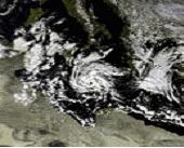
January 14-18, 1995
In the middle of January 1995, a cold front moved across the Mediterranean Sea. A
frontal wave developed along it on the 13th, and developed a low-level circulation the next day to the west of Greece. Convection built and organized around the center as it moved to the southwest, and by the 15th it resembled a tropical storm. It continued to
organize, and
developed an eye later that day. Though water temperatures were only 16 °C (61 °F), the storm was characterized by well-defined outflow, an eye, an upper level anticyclone, and a ship report of 136 km/h, 37.8 m/s (74 knots, 85 mph) winds, equivalent in strength to a
Category 1 hurricane. The system continued to the southwest and quickly weakened, making landfall on northern Libya as a convectionless vortex on the 17th. It dissipated the next day.
October 4-6, 1996
On October 4, 1996, a small vortex was first observed between Sicily and Tunisia. It
moved to the north-northeast, and quickly organized due to warm water temperatures. The system may have tried to develop a warm core, but only limited shallow convection was seen within its circulation. It passed over Sicily on the night of the 4th and crossed southern Italy
on the 5th. By the 6th, it entered the Adriatic Sea and dissipated.
The storm caused extremely intense precipitation and severe floods in Sicily and over the southern part of Calabria (480 mm over 2 days, with 285 mm on 4 October alone). It
produced gusts of up to 105 km/h, 29 m/s (55 knots, 65 mph), causing heavy damage in its short path.
October 6-10, 1996
As the previous system was at its peak, a frontal wave extended through the western
Mediterranean. It developed into a frontal low on the 6th, and strengthened and became better
organized as it moved eastward over warm waters. With little upper level shear, a warm core, an organized vertical structure, and a n eyewall, the system was possibly a
hurricane late on the 7th just before hitting Sardinia. Over land it lost its eye structure, but quickly reorganized and acquired an eye early on the 8th after crossing Sardinia. reached
hurricane strength the same day in the Tyrrenian sea. The storm retained its organization for a day before hitting northern Sicily on the 10th and weakening. Floods occurred on the Balearic Islands, Sardinia, and south Italy. On the 9th, serious damage from winds up to 145 km/h (78 knots) was reported over the Eolian Islands. Four people were reported dead.
The development of a hurricane in the central Mediterranean Sea was well-predicted by
computer models in the days prior to the storm's genesis.
March 27-28, 1999
A deep cyclone cutoff in the Gulf of Lyons on March 26. Winds at Portbou, Spain
increased to 150 km/h, 41.6 m/s (81 knots, 93 mph) by the evening of March 26. The
pressure of the cyclone fell to 998 hPa by midnight. By the morning of March 27, it was no longer connected to its occluded front and satellite imagery briefly revealed an eye feature, though convection around it was shallow. Water temperatures under the system were a mere 15°C (59°F) since temperatures at the 500 hPa level were quite cold; -28°C (-18°F). Soon
afterwards, the system weakened as it approached northern Italy.
See also
South Atlantic tropical cyclone
Tropical cyclogenesis#Unusual_areas_of_formation
List of notable tropical cyclones#Unusual_landfalls
Medicanes - Mediterranean Hurricanes
Tropical like Mediterranean Storms - An analysis from Satellite
Thanks to thefullwiki.org for the information.
|
|